Re-imagining navigation software to support exploring
The rapid spread of GPS-enabled smartphones since the early 2000s has fundamentally changed navigation in the city. Interaction Designer Laura de Groot explored the potential downsides of mobile navigation software and re-imagined navigation software to support exploring.
How we move through the urban landscape has transformed with the presence of digital technology. One piece of urban technology that has had a lot of effect on mobility and behaviour in the city is navigation apps (Google Maps, TomTom, open street maps, etc.) The rapid spread of GPS-enabled smartphones since the early 2000s has fundamentally changed navigation in the city. We no longer get lost and do not have to ask our way, even in cities foreign to us. Current navigation systems offer a lot of convenience. While the advantages of these technologies are evident, this exploration seeks to uncover potential drawbacks that might have been overlooked during this technological transition.
Can we re-integrate some of these potential drawbacks back into our navigation software?
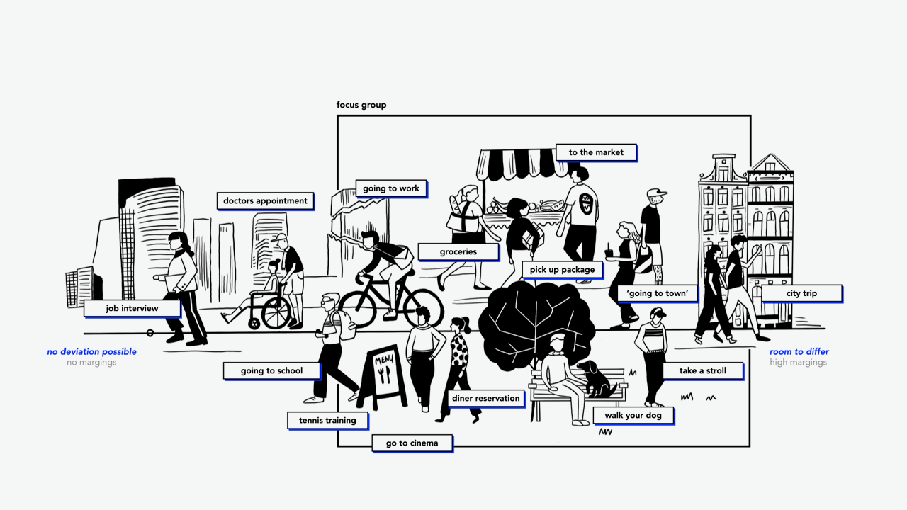
Current navigation systems assist those with rigid schedules and fixed destinations: they provide confidence and certainty that you will reach a specific place at a specific time. Even if you take the wrong turn, the navigation recalculates and guides you back on track. However, some people do not have these strict margins to get somewhere, meaning having more time and space to differ. Conversations about past experiences with navigation, interviews with academics, and new articles unveiled four primary areas of elements that could be rethought in current navigation systems for this focus group.
Potential areas to reimagine navigation
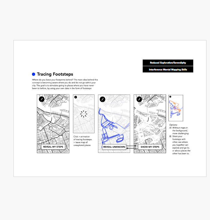
- Reduced sense of direction: We depend on technology, as it knows the surroundings better than ourselves. This interferes with developing our mental mapping skills, distracts our attention from the environment, and changes our perception of distance and time.
- Loss of adventure: Our focus has shifted from journey to reaching the destination. Becoming less patient whilst traveling and focusing on efficiency, there is less room for exploration and serendipity. Reaching our destination no longer gives a sense of accomplishment.
- Being sensed: Navigation is often based on car-centric data, comes with privacy concerns of GPS tracking, and can be used for commercial exploitation. Can we use this data in the city and citizens benefit? What other layers of data could we involve?
- Reduced sense of community: There is no longer the need to ask others for directions or recommendations, as navigation software has taken over these tasks. People do not need to ask anymore on one side, while locals no longer need to have this local knowledge anymore. However, these little social interactions with strangers can contribute to our subjective well-being in everyday life.
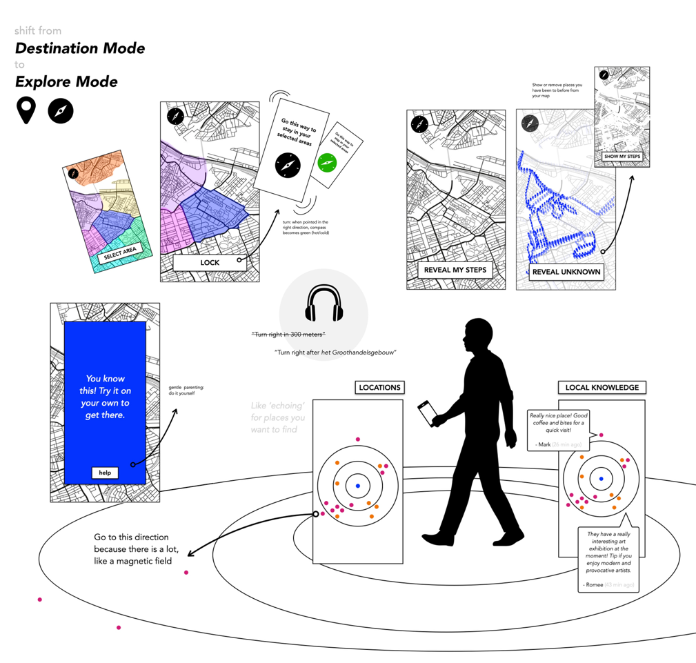
The ability to look up directions and locations independently removed the need to engage with locals for guidance. The reciprocal effect is that locals no longer need to be walking directories, as there is no need to remember details. From a city’s perspective, this loss of local knowledge could also be an interesting element in navigating urban space that might have gone lost. As a local, do you still explore and stumble upon new experiences in your own city? This is the starting point for exploring alternative concepts that could redefine our navigation experience. For example, what would navigation look like if it stopped giving you instructions? Or, what if it removed where you have been before from the map? Would it stimulate you to visit places new places? What if geo-tagged information would only become available if you are nearby? Can navigation software support you to wander around, without getting too far away from your starting point? These different ideas are visualized in the report.
Next steps?
For future research, I think it is interesting to conceptualize how navigation software can support us to become smarter, instead of dumber in the future? How can we stimulate active thinking or planning? How can navigation software support its users in navigating on their own, with the goal of not needing the software in the end?
Human Navigational Aids for the City an exploration into potential downsides of mobile navigation software
Laura de groot - Interaction Designer
The rapid spread of GPS enabled smart phones since the early 2000s has fundamentally changed navigation in the city. We do no longer get lost, do not have to ask our way, even in cities foreign to us. Current navigation systems offer a lot of convenience. While the advantages of these technologies are evident, this exploration seeks to uncover potential drawbacks that might have been overlooked during this technological transition. “Can we imagine an alternative to current navigation systems?“

Laura de Groot
Interaction Designer

Hein Wils
Programmamanager Digitalisatie & Innovatie, gemeente Amsterdam